 St. Cecelia's Golden Knights Cheerleaders and Football Players have rescheduled their car wash. Mark your calendars! It will be held on September 10,
at the St. Cecelia’s parking lot. The car wash will run from 9 – 3.
It will cost $5.00 per car. So c'mon out and support the kids in our
community, who are trying to work hard so they can raise a little money
for their activities!
St. Cecelia's Golden Knights Cheerleaders and Football Players have rescheduled their car wash. Mark your calendars! It will be held on September 10,
at the St. Cecelia’s parking lot. The car wash will run from 9 – 3.
It will cost $5.00 per car. So c'mon out and support the kids in our
community, who are trying to work hard so they can raise a little money
for their activities!
Wednesday, August 31, 2011
Golden Knights Car Wash Rescheduled
St. Cecelia's Golden Knights Cheerleaders and Football Players have rescheduled their car wash. Mark your calendars! It will be held on September 10,
at the St. Cecelia’s parking lot. The car wash will run from 9 – 3.
It will cost $5.00 per car. So c'mon out and support the kids in our
community, who are trying to work hard so they can raise a little money
for their activities!
FREE CONCERT at Parker Press Park in Woodbridge

8/31 Delta Rae with Blues and Folk
JFK Marching Band Fundraiser Today
 Today - Wednesday, August 31 - from 5:00pm - 9:00pm
the John F. Kennedy High School Marching Band will be holding a fundraiser at MaggieMoos of Edison (located at 1655 Oak Tree Road.)
Please come out to Maggie Moos tonight and enjoy some great ice cream with the JFK marching band!!!! I hope to see you ALL there : D ♥ What a great treat during those long summer days of Band Camp!!!
Tuesday, August 30, 2011
Tell me your story....
It's almost September, and I've been thinking a lot about September 11th. Everyone has a story about where they were and what they did on September 11th, especially this close to New York. I was wondering if you would tell me your story? Email me at iselin.home@yahoo.com and let me know... I want to write a 'remembrance' post on the 11th. Thanks!
Blood is Needed - Mark your Calendar!
I just read on Facebook that 2000 + units of blood were lost from shutdowns and power outages.
Can you donate blood? If you can, please do! On Friday, September 2nd from 2-8p there will be a blood drive at the Woodbridge Community Center/YMCA, 600 Main St, Woodbridge.
I hear that every donor will receive a pair of NJ Nets tickets and Rita's Italian Ice. You should bring your ID. Please let your friends know. Help save lives... THANK YOU!
Eid Mubarek
From Wikipedia:
"Current reports from various sources have estimated that 1.2 to 1.57 billion Muslims populate the world, or about 23% of an estimated 2009 world population of 6.8 billion..."
"Eid ul-Fitr, often abbreviated to Eid, is a Muslim holiday that marks the end of Ramadan, the Islamic holy month of fasting. Eid is an Arabic word meaning "festivity," while Fiṭr means "breaking (the fast)". The holiday celebrates the conclusion of the twenty nine or thirty days of dawn-to-sunset fasting during the entire month of Ramadan....
....Eid ul-Fitr is celebrated for one, two or three days. Common greetings during this holiday are the Arabic greeting ‘Eid Mubārak ("Blessed Eid") or ‘Eid Sa‘eed ("Happy Eid"). In addition, many countries have their own greetings based on local language and traditions. Muslims are also encouraged on this day to forgive and forget any differences or past animosities that may have occurred with others during the year....
Although the date of Eid ul-Fitr is always the same in the Islamic calendar, the date in the Gregorian calendar falls approximately 11 days earlier each successive year, since the Islamic calendar is lunar and the Gregorian calendar is solar. Hence if the Eid falls in the first ten days of a Gregorian calendar year, there will be a second Eid in the last week of the same Gregorian calendar year. The Gregorian date may vary between countries depending on the local sightability of the new moon. Some expatriate Muslim communities follow the dates as determined for their home country, while others follow the local dates of their country of residence. In the Islamic calendar, a new day, and therefore also Eid ul-Fitr, begins at sunset."
The Quote of the Day
The
problem is not that there are problems.
The problem is expecting
otherwise
and thinking that having problems is a problem.
~Theodore
Rubin
Monday, August 29, 2011
JFK Freshman Orientation
Do you have a son or daughter starting High School this year in Iselin? Well, John F. Kennedy Memorial High School's freshman orientation will be held at the school Tuesday, August 30, 2011, at 10:00 AM.
Yes, folks, it's back to school!
Yes, folks, it's back to school!
The Infernos IS RE-SCHEDULED FOR TOMORROW
every Monday night in July and August at 7:30 p.m. on the stage behind Woodbridge High School. It was rescheduled for tomorrow because of the storm.
Tomorrow's music is the last of the series. Come out and enjoy “The Infernos"!
Seating is not provided, so remember to bring a lawn chair or
blankets and donate a non-perishable food item.
Mark your Calendars Now:
Iselin Giants - Adult Fundraiser
The Iselin Giants organization is holding an adult fundraiser to benefit the children ages 5 - 15 playing football and cheering for the Iselin Giants Pop Warner organization.
The event will be held on Saturday, September 10 · 12:00pm - 10:00pm at Big Shots, on Rt. 1 in Iselin.
Admission is $10 at the door and includes:
* Buffet * Discounted Drinks * 50/50 * Raffles

glitter-graphics.com
Admission is $10 at the door and includes:
* Buffet * Discounted Drinks * 50/50 * Raffles
glitter-graphics.com
Sunday, August 28, 2011
Power Outages
At first, I couldn't quite figure out what these photos were. My friend emailed them to me, and she said that the sidewalk had MELTED! The photos were taken on Middlesex Turnpike in Iselin near the post office. Can you tell what they are? A downed power line! (I'm assuming that everyone stayed at a safe distance while the lines were live, right? Because that looks DANGEROUS!)
So that's one of the reasons for all of the power outages. Another reason I hear is "transformer fires."
And a lot of my friends were being told that the power would not be restored until September 4th or 5th. BUT all day, I've been hearing from people, a few at a time, "HEY! My power's back!" It's great to see progress so quickly.
It should all be a distant memory by September. I hope.
 |
| Photo Credit Tal Zahn |
 |
| Photo Credit Tal Zahn |
So that's one of the reasons for all of the power outages. Another reason I hear is "transformer fires."
And a lot of my friends were being told that the power would not be restored until September 4th or 5th. BUT all day, I've been hearing from people, a few at a time, "HEY! My power's back!" It's great to see progress so quickly.
It should all be a distant memory by September. I hope.
The Quote of the Day
The
trouble with weather forecasting
is that it's right too often for us to
ignore it
and wrong too often for us to rely on it.
~Patrick Young
The After Video for the Brook
This is the video I took of the brook AFTER the hurricane... HOURS after. Usually, the waters have subsided already when that much time has gone by. We're talking a LOT of water.
(Email subscriptions don't show videos; come right to the Iselin Times to see it!)
(Email subscriptions don't show videos; come right to the Iselin Times to see it!)
Rumors and Information...
One of the reasons that I find Facebook and Twitter so fascinating is because you hear so much about what's going on. Or what people THINK is going on. Sometimes it's true. Sometimes it's just a rumor. Who knows for sure? So... here are some of the things I read just now on Facebook. True or not??? I have no idea! What have you heard?
- Shop Rite in Woodbridge is closed today, and they'll open at 6 AM tomorrow.
- Someone was caught trying to LOOT the Home Depot in Woodbridge - BUT if that's true, I think they were arrested. (Again - this is rumors, people! I'm hoping it's not true! And if it is true, I hope they go to jail... c'mon, people, we're supposed to be a civilized society!!!)
- A sink hole opened up in Port Reading, which could be a water main break. (I'm going to try to find out.)
More Photos of Irene's Floods
Flooding in Metropark
Streets in Colonia waiting for the water to recede...
There are also many reports of power outages throughout our town.
 |
| Photo by C. Callahan |
Streets in Colonia waiting for the water to recede...
 |
| Photo by TJ Puff |
 |
| Photo by TJ Puff |
There are also many reports of power outages throughout our town.
Photos Around Iselin

Well, it seems that we all got through the storm, a bit worse for the wear but hopefully all safe. The Governor has said that everyone should stay off the streets... and I would totally agree with that. For some reason, though, a lot of people with jobs - even teenagers - are still expected to get to work, and like it or not, a lot of them are on the roads. And there are a LOT of emergency service workers out as well.


Saturday, August 27, 2011
Tornado WATCH - not Warning! Don't panic!
Ok, so we have a Tornado Watch here in Middlesex County. But that is NOT the same thing as a warning! Tornado watches just mean it's POSSIBLE, not that there IS a Tornado! This is what the alert said:
(UPDATE: THE NATIONAL WEATHER SERVICE HAS ISSUED TORNADO WATCH 812 UNTIL 5 AM EDT SUNDAY WHICH REPLACES A PORTION OF TORNADO WATCH 811.
Sat, Aug 27, 2011, 6:15 PM EDT
THE NATIONAL WEATHER SERVICE HAS EXTENDED TORNADO WATCH 811 TO INCLUDE THE FOLLOWING AREAS UNTIL 8 PM EDT THIS EVENING
IN NEW JERSEY THIS WATCH INCLUDES 4 COUNTIES
MONMOUTH
MIDDLESEX
BURLINGTON
and OCEAN
THIS INCLUDES THE CITIES OF... EAST BRUNSWICK... EDISON... FREEHOLD... MOORESTOWN... MOUNT HOLLY... NEW BRUNSWICK... NORTH BRUNSWICK TOWNSHIP... PERTH AMBOY... SAYREVILLE AND TOMS RIVER.
Here are the definitions:
Tornado Watch: A tornado watch means that conditions are favorable for the development of severe thunderstorms and multiple tornadoes in and close to the watch area. People in the affected areas are encouraged to be vigilant in preparation for severe weather.
Tornado Warning: A tornado warning means that a tornado has been sighted by spotters or indicated on radar, and is occurring or imminent in the warning area. If a tornado warning is issued, people in the affected area are strongly encouraged to take cover immediately.
Being Prepared for a tornado means get ready now, so read this:
When a tornado warning has been issued, you may have very little time to prepare.
How you respond now is critical. And how you react depends on where you are.
In a Frame Home (most of us have Frame homes. That's a regular building.)
(UPDATE: THE NATIONAL WEATHER SERVICE HAS ISSUED TORNADO WATCH 812 UNTIL 5 AM EDT SUNDAY WHICH REPLACES A PORTION OF TORNADO WATCH 811.
IN NEW JERSEY THE NEW WATCH INCLUDES 7 COUNTIES
MONMOUTH
MIDDLESEX
ATLANTIC
BURLINGTON
CAPE MAY
CUMBERLAND
OCEAN
But SO FAR, we still haven't seen a tornado in Middlesex County. But keep watching the weather channel for minute by minute updates!
But SO FAR, we still haven't seen a tornado in Middlesex County. But keep watching the weather channel for minute by minute updates!
Here are the definitions:
Tornado Watch: A tornado watch means that conditions are favorable for the development of severe thunderstorms and multiple tornadoes in and close to the watch area. People in the affected areas are encouraged to be vigilant in preparation for severe weather.
Tornado Warning: A tornado warning means that a tornado has been sighted by spotters or indicated on radar, and is occurring or imminent in the warning area. If a tornado warning is issued, people in the affected area are strongly encouraged to take cover immediately.
Being Prepared for a tornado means get ready now, so read this:
When a tornado warning has been issued, you may have very little time to prepare.
How you respond now is critical. And how you react depends on where you are.
In a Frame Home (most of us have Frame homes. That's a regular building.)
Ideally, you should avoid driving when tornadoes or other kinds of dangerous weather threaten, because a vehicle is a very unsafe place to be. If, however, this is not possible, stay as calm as possible, and assess the situation. |
A photo from Woodbridge Center
 |
| Photo from Kerry Blaze |
Friday, August 26, 2011
A Photo from ShopRite in Woodbridge
 |
| Photo by TJ Puff |
I hope you already got all the bread you need. This photo shows that the cupboard is bare over at Shop Rite! I wonder if there was any bisquick left, because I'm in the mood to make pancakes!
CAR WASH TOMORROW

"Will I be safe in Hurricane Irene?"

Do you have a crystal ball, to see the future? I wish I did!
A lot of people are worrying about the Hurricane. And that's actually a very good thing, because if you are worried, you are probably making plans to keep yourself safe. I'm more worried about people who AREN'T worried, because they aren't going to be prepared.
I can see a lot of the terms people use when they search and find my site, the Iselin Times. One of those terms today has been, "Will Iselin be safe in Hurricane Irene?" and other variations of that.
No one - not even the almighty GOOGLE - can tell the future. I sure hope that Iselin will be safe in the storm. But the fact is, you need to take steps to be prepared. You need to absolutely listen to the people in charge of our town's emergency management, and do what they say. If they say EVACUATE, you need to follow their directions. I don't plan on going anywhere; I've taken all of the reasonable precautions that are being suggested. BUT if the police or fire department knock on my door and say "go", I'm going, and you better too! Your belongings aren't worth as much as your life. And the Emergency Management people study this stuff, and they are only looking out for your best interests.
On the other hand, it also isn't a good idea to start freaking out and scare yourself to death. Because chances are good that everything is going to be fine. Be prepared, yes. Be careful, yes. Educate yourself, yes. PANIC??? NO. Because when you are PANIC-stricken, you aren't making sensible decisions, and that won't help you stay safe either.
And, most importantly of all - especially if you are a kid, and you're googling this stuff because you are worried - don't plan on going out in the storm. Especially in the "eye" - the middle of the storm, when it could get calm all of a sudden. Make sure the storm is actually OVER for GOOD first. Because the strongest winds of all are usually found surrounding the eye of the storm, and if you go out, thinking it's clearing, you risk being in a dangerous place when the winds slam back on the other side of the eye. From an Official Government Hurricane Information Place:
How long does the eye last? ...Well, that's hard to say. How fast is the hurricane moving? Most hurricanes may move along at 10-20 mph, but in extreme cases, they could be moving as fast at 40 mph (pretty rare), or go much more slowly, or even stall out (“quasi-stationary” as they are called). How big is the eye? The average eye is 10-40 miles in diameter, but the extremes would be 5-60 miles wide.
How close does the exact center of the eye come to you? If the exact center of the eye comes across your location, you will be in the eye longer than if you are just brushed by the edge of the eye. It is important to realize that most people who are “hit” by a hurricane never actually get into the eye at all because the storm itself is so large compared to the eye. Those who do encounter the eye usually get the worst winds because they go through the eyewall...twice!
And finally - the flood waters, which we are pretty sure to get in a lot of places around town, are NOT places to play.
One of the only two Woodbridge Police Officers who ever died in the line of duty here in Woodbridge Township, died specifically because of this: kids, thinking that it would be fun to be out after a hurricane, and playing in or near the water - by the brook or in a flooded parking lot - got swept away. He tried to save them, but couldn't. From the article in the Patch:
Detective Bruce Chester, who was working with the Woodbridge Police Department and knew Williams at the time of his death, still vividly remembers the details of the day Williams died.
“The hurricane had stopped, everything was flooded,” Chester said. “I got the call; I was about 30 seconds from [the scene of Williams’ death]. When I arrived it was a very eerie scene – very, very eerie. There were black clouds all over the place, water all over the place – I knew that something was very wrong.”
“When I arrived – obviously, Alvin had tried to save these two children – they were all swept under this pipe that goes under [the river],” he said. “To have that kind of job as a young officer – that was 32 years ago and I’m still on the job now – it’s something that I’ll never forget, and every time I come by here I always look over to that scene where Alvin tried to save those two children. Sometimes it raises the hair on my back.”
Things you SHOULD BE DOING NOW -
Hurricane Preparation
Well, my friends, it's looking like the storm could very well be a bad one, and so now is the time to prepare. Hey, it's better to be safe than sorry! Anyway, the Disaster Supply Kit list is from the National Hurricane Center; the notes in red are mine. Plus, I highlighted the things I think are most important.
JOB ONE: Clean up your yard! Everything outside that can blow around should be put AWAY somewhere.
Am I boarding up my windows? No. Should I be? I'm not sure. My husband and I figure that the biggest problem will be the stuff that could blow around, and if we have that stuff put away, we're hoping it will be fine.
JOB TWO: GATHER WHAT YOU NEED!

Bring the things from your disaster kit - this is where the blankets and things are needed.
Hopefully, the whole thing blows over and we're all left laughing about it and making fun of the weather channel next week. That is way better than the alternative!
JOB ONE: Clean up your yard! Everything outside that can blow around should be put AWAY somewhere.
Am I boarding up my windows? No. Should I be? I'm not sure. My husband and I figure that the biggest problem will be the stuff that could blow around, and if we have that stuff put away, we're hoping it will be fine.
JOB TWO: GATHER WHAT YOU NEED!
JOB THREE: LEAVE if you are told to evacuate, and convince your friends and family to do the same! If you aren't sure where to go, email me and I'll help you figure it out. NO ONE should risk the lives of emergency workers just because they are stubborn.Water - at least 1 gallon daily per person for 3 to 7 days You don't have to BUY it, if you have old milk jugs or soda bottles in the recycling, wash them out really well and then run the water in them. I'm freezing some too, just to help keep my food cold.
— non-perishable packaged or canned food / juices Not milk and eggs though
— foods for infants or the elderly
— snack foods Best food ever? POP TARTS! and Peanut butter and jelly
— non-electric can opener
— cooking tools / fuel -- Maybe propane or charcoal for your grill?
— paper plates / plastic utensils Washing dishes is harder if the water isn't working!
— insurance, medical records, bank account numbers, Social Security card, etc.
— proper identification / immunization records / medications
— ample supply of food and water
— a carrier or cage
— muzzle and leash
Bring the things from your disaster kit - this is where the blankets and things are needed.
Hopefully, the whole thing blows over and we're all left laughing about it and making fun of the weather channel next week. That is way better than the alternative!
THIS JUST IN: a press release from Town Hall
WOODBRIDGE POSTS REVISED STORM ALERT FOR SAT., AUG. 27 THRU SUN., AUG. 28WOODBRIDGE – Mayor John E. McCormac today announced that the National Weather Service Hurricane Center has posted a Hurricane Watch for the Woodbridge area for Sat., Aug. 27 thru Sun.,. Aug 28. A Hurricane Watch means that hurricane conditions are expected within the watch area. The National Weather Service predicts sustained winds, rainfall of 8 to12 inches, and above normal tides may potentially impact the Woodbridge area from 2:00 P.M. on Sat., Aug. 27 through Sunday PM (Aug. 28).The Woodbridge Township Office of Emergency Management is closely monitoring storm conditions. Woodbridge Township residents and business-owners in flood-prone areas are reminded to move vehicles to higher ground and to be prepared to undertake emergency procedures should the Office of Emergency Management issue specific storm-related warnings. Residents are encouraged to develop a storm plan in the event of an evacuation notice and to stock-up on non-perishable foods, bottled water, batteries, and a battery-operated radio.Residents and business-owners in the flood-prone areas of Crampton Avenue, Watson Avenue, Heidelberg Avenue, Vesper Avenue, Pearl Avenue, and Von Vetchen Avenue in Woodbridge proper and residents in the Ideal Home Park and surrounding areas in Avenel (East Coddington St., St. Mary Way, Jay St., Freddie Alison Drive, Joey Lane, Jessie Lane, Christina Drive, Helen Ave. and Coke Ave.) are reminded to move vehicles to higher ground and to be prepared to undertake emergency procedures should the Woodbridge Township Office of Emergency Management issue specific storm-related warnings.The Woodbridge Township Office of Emergency Management, the Woodbridge Police Department, and the Department of Public Works will continue to monitor local storm conditions and are positioned to implement appropriate public safety alerts and operations should the storm result in flooding of low-lying areas. Should evacuation of flood-prone areas become necessary, residents will be notified via Reverse 9-1-1 or door-to-door notification. A shelter location will be established at the Woodbridge Community Center ( Main Street , Woodbridge ) and other locations should the need arise. The shelter centers will open in the event of mandatory evacuation. No evacuation has been issued at this time.All Woodbridge Township personnel are on stand-by status. The Department of Public Works will be stationed at key areas throughout the Township to maintain highways and clear debris during and after the storm. The WPD and the Office of Emergency Management are fully staffed and will be on-duty throughout the storm. The Office of Emergency Management has established communications with the Middlesex County Office of Emergency Management and Township utility and service agencies, including PSEG, NJNG, Middlesex Water Co., MCUA, RVSA, and critical public service agencies. All Woodbridge Township fire departments, ambulance services, Community Emergency Response Team, and Auxiliary police officers are on alert status and are available to respond to any emergency situation anywhere in the Township.Woodbridge Township residents should tune to local TV news and weather reports, TV-35, or log-on to the Township Web Page at: www.twp.woodbridge.nj.us for specific storm-related announcements. For updated storm and weather-related information, go to the Woodbridge Township web page at: www.twp.woodbridge.nj.us or the New Jersey Office of Emergency Management web page at: http://www.ready.nj.gov/plan/kit-plan.html.
Thursday, August 25, 2011
Hurricane Irene... continued...
New Jersey has already declared a state of emergency!
Long Beach Island will be under a mandatory evacuation order at 8 a.m.
Friday, municipal and Ocean County emergency officials said this
afternoon.
HURRICANES and TROPICAL STORMS: THE DANGERS
The key threats from an approaching Tropical Storm or Hurricane are WIND, STORM
SURGE, FLOODING, and the potential for TORNADOES. HURRICANES and TROPICAL STORMS: THE DANGERS
- Hurricane WINDS can reach 74-95 mph for a Category 1
storm, to above 155 mph for a Category 5 storm.
- The STORM SURGE is a dome of ocean water the hurricane
pushes ahead of itself. At its peak a storm surge can be 25 feet
high and 50-100 miles wide. The storm surge can devastate coastal
communities as it sweeps ashore.
- The thunderstorms and torrential rains that accompany a hurricane
can create dangerous and deadly FLOODS or FLASHFLOODS.
- Seventy percent of hurricanes making landfall spawn at least one TORNADO.
Saint Cecelia Golden Knights Food Drive

Iselin Library Remains Closed
New Date!!! The Iselin Branch will remain closed for an HVAC upgrade until September 6th, 2011. Please remember that the Iselin book drop is open, or you can return your items at the Main, Fords, or Henry Inman branches. Books on hold will also be available for pick-up at the Main Library.
Yard Sale Days
It might seem like a strange time to mention Woodbridge's yard sale days, and special pick up days, but I have a very good reason.
This is gonna be a GREAT weekend to stay indoors. So I'm planning on going through my attic, and pulling stuff out for my sale... but I think I might try to sell my stuff at the flea market that's going to be at St. Cecelia's on September 24th. It's being sponsored by the St. Vincent dePaul Society, and a spot there will cost $15 (without a table.) I've gotta remember to call Jean or Jerry Retkwa at 732-283-2312, so I can ask them to hold a spot for me!
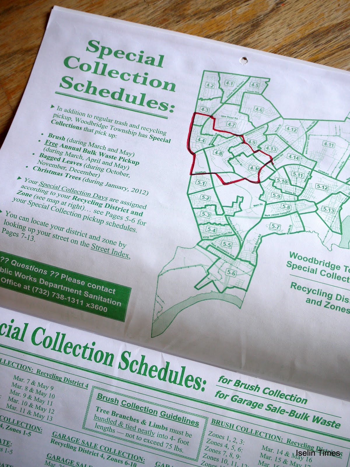
But anyway - I checked the Woodbridge Township recycling calendar so I could find out when our "special pick up" days are. They have the whole town divided into separate districts, and each district has a few different zones. If you aren't sure which district/zone you are in, you should go check the website HERE. It's a 32 page PDF document, everything you need to know about recycling and garbage pick-up in Woodbridge.
I found my own district/zone number. It seems like Iselin is all district 4, mostly zones 4,8, and 10, and little pieces of zones 3, 7, 9, and 13. (But I could be wrong, so you really need to go look through that pdf file to see where you are. Don't take my word for it, because you don't want to miss your chance!)
The dates I found for Iselin:
zones 4-10 and 4-13 will have their yard sale on September 10th and 11th.
zones 4-3, 4-4, 4-7, 4-8 and 4-9 will have their yard sale on September 17th and 18th.
Special Bulk Pick Ups:
9/13/11 for Zone 4-13
9/16/11 for Zone 4-10
9/19/11 for Zone 4-9
9/20/11 for Zone 4-8
9/21/11 for Zone 4-7
9/24/11 for Zone 4-3 and 4-4
I love the day of bulk pick up, you get to watch everyone driving around picking through everyone else's garbage - always entertaining, and actually not a bad thing at all; sorta another way to recycle. If I put anything on the curb that you want, feel free to take it!

Residents participating in the garage sale weekend can advertise their garage or yard sale on the Township web page by logging on to: www.twp.woodbridge.nj.us.
Wanna know who is having a yard sale and when? Click HERE!
Fall 2011 Special Collection Guidelines:
Have your garage sale on Saturday & Sunday… what you don’t sell or give away will be picked up FREE the following week. Place discarded items at curbside after 4:00 pm the Sunday after your garage sale weekend. The bulk waste items will be collected according to the District/Zone schedule for your street.
Bulk Waste Items Include: Furniture, Wood, Carpeting, Appliances & Mixed Metals. Concrete, Brick and Block will be collected by appointment only; to schedule an appointment for the collection of concrete, brick or block, call 732-738-1311 x3043. No Hazardous Waste, Tires, Paint, or Chemicals will be accepted. The FREE bulk waste collection program is for Woodbridge Township Residents only!
Contact the Woodbridge Township Department of Public Works at 732-738-1311 x3035 or 3049 or log-on to the Woodbridge Township Web page at: www.twp.woodbridge.nj.us for more information about the FALL 2011 bulk waste collection program.
This is gonna be a GREAT weekend to stay indoors. So I'm planning on going through my attic, and pulling stuff out for my sale... but I think I might try to sell my stuff at the flea market that's going to be at St. Cecelia's on September 24th. It's being sponsored by the St. Vincent dePaul Society, and a spot there will cost $15 (without a table.) I've gotta remember to call Jean or Jerry Retkwa at 732-283-2312, so I can ask them to hold a spot for me!
But anyway - I checked the Woodbridge Township recycling calendar so I could find out when our "special pick up" days are. They have the whole town divided into separate districts, and each district has a few different zones. If you aren't sure which district/zone you are in, you should go check the website HERE. It's a 32 page PDF document, everything you need to know about recycling and garbage pick-up in Woodbridge.
I found my own district/zone number. It seems like Iselin is all district 4, mostly zones 4,8, and 10, and little pieces of zones 3, 7, 9, and 13. (But I could be wrong, so you really need to go look through that pdf file to see where you are. Don't take my word for it, because you don't want to miss your chance!)
The dates I found for Iselin:
zones 4-10 and 4-13 will have their yard sale on September 10th and 11th.
zones 4-3, 4-4, 4-7, 4-8 and 4-9 will have their yard sale on September 17th and 18th.
Special Bulk Pick Ups:
9/13/11 for Zone 4-13
9/16/11 for Zone 4-10
9/19/11 for Zone 4-9
9/20/11 for Zone 4-8
9/21/11 for Zone 4-7
9/24/11 for Zone 4-3 and 4-4
I love the day of bulk pick up, you get to watch everyone driving around picking through everyone else's garbage - always entertaining, and actually not a bad thing at all; sorta another way to recycle. If I put anything on the curb that you want, feel free to take it!
Residents participating in the garage sale weekend can advertise their garage or yard sale on the Township web page by logging on to: www.twp.woodbridge.nj.us.
Wanna know who is having a yard sale and when? Click HERE!
Fall 2011 Special Collection Guidelines:
Have your garage sale on Saturday & Sunday… what you don’t sell or give away will be picked up FREE the following week. Place discarded items at curbside after 4:00 pm the Sunday after your garage sale weekend. The bulk waste items will be collected according to the District/Zone schedule for your street.
Bulk Waste Items Include: Furniture, Wood, Carpeting, Appliances & Mixed Metals. Concrete, Brick and Block will be collected by appointment only; to schedule an appointment for the collection of concrete, brick or block, call 732-738-1311 x3043. No Hazardous Waste, Tires, Paint, or Chemicals will be accepted. The FREE bulk waste collection program is for Woodbridge Township Residents only!
Contact the Woodbridge Township Department of Public Works at 732-738-1311 x3035 or 3049 or log-on to the Woodbridge Township Web page at: www.twp.woodbridge.nj.us for more information about the FALL 2011 bulk waste collection program.
My Facebook Poll about the Hurricane
I made up this Facebook Poll -- what are you doing to prepare for the hurricane? I'm really curious, so please click on this link HERE and answer the poll! You might need to make friends with the Iselin Times on Facebook first... my page is www.facebook.com/IselinTimes. (I won't blow up your newsfeed with tooo many posts, promise!)
The reason I'm doing this poll is because I'm really trying to figure out, what is the appropriate level of action that needs to be taken to prepare for Hurricane Irene? Although I guess the only way that anyone will be able to answer that question with any real confidence is AFTER the fact.
I am a Boy Scout, so I really believe in BEing PREPARED! And there are plenty of web pages with information on what you should do to be prepared; you can find one HERE, from the National Hurricane Center. As my family will tell you, I'm also a nervous nelly. I worry about everything. But that's what's great about me and my husband; we balance each other out. I worry about everything, and he worries about nothing, and everything works out fine in the end. (And if it isn't fine, it isn't the end!)
The question of how to prepare really started last night, when the weather channel started really talking about Irene hitting OUR area. And like a friend of mine said... New York, now THAT is a city unprepared to deal with a Full On Hurricane!
So - there are little things that I am doing to be prepared, things that certainly won't hurt. I have plenty of canned food (And a non-electric Can Opener!) and bottled water. I have flashlights and candles. I'm going to run to the store to pick up some batteries. I'm going to clean up my yard, and anything that could become a projectile is going to be picked up and put away. I'm going to check on friends and family that live in areas that could be sketchy, and ask them if they'd feel safer at my house - BEFORE the weather gets bad!
But the big question for me is this: How bad does the forecast have to be, for it to be a good idea to board up windows?
I always see those pictures of people boarding up their windows down south. I've never seen anyone board up a window around here. But obviously, you won't want to board them up when the hurricane is ON you. And I guess it isn't really the force of the wind hitting the window that's the problem... it's the force of the stuff that's blowing around. Like the tree limbs, or garbage cans, or whatever. How much lead time do you have? And... will Home Depot have enough plywood? And... will the Home Depot parking lot have already flooded out anyway?
Ah, well, for the answer to these and other questions, come back next week after the Hurricane is over.
But for now, please answer my poll!
The Quote of the Day
“Your time is limited, so don’t waste it living someone else’s life. Don’t be trapped by dogma – which is living with the results of other people’s thinking. Don’t let the noise of other’s opinions drown out your own inner voice. And most important, have the courage to follow your heart and intuition. They somehow already know what you truly want to become. Everything else is secondary.” - Steve Jobs
from Macstories.net
Wednesday, August 24, 2011
Good Night, Irene
A little music to contemplate the weather by...
Oh yeah - and that reminds me - there are only 122 days until Christmas!
Oh yeah - and that reminds me - there are only 122 days until Christmas!
How 'bout flooding BEFORE the Hurricane even hits us???
I received this press release from the Mayor's Office this morning.
They are saying that tomorrow, WAY BEFORE Hurricane Irene hits us on Saturday or Sunday, there is going to be ANOTHER storm.
And considering how water-logged we are already, they're expecting it to be floods.
I'll keep an eye on the creek for ya. Maybe I'll even get a few photos, who knows?
And let me know if you hear anything about locusts...
The Woodbridge Township Office of Emergency Management and the National Weather Service has issued a storm and flood watch advisory for Thurs., Aug. 25, 2011. This alert is unrelated to Hurricane Irene which is not expected to impact the Woodbridge Township area until Sat., Aug. 27. The Woodbridge Township Office of Emergency Management will issue a separate advisory regarding Hurricane Irene.
The National Weather Service reports that a cold front is expected to move through the state on Thurs., Aug. 25, 2011. Thunderstorms with strong winds and heavy rains are forecast for the afternoon and evening hours of Thurs., Aug. 25 into Fri., Aug. 26. It is anticipated that the storm – which is unrelated to Hurricane Irene – will produce more than 2+ inches of rain in the Woodbridge area, accompanied by heavy wind gusts, with the potential for flash-flooding along creeks and streams and in low-lying areas and streets routinely subject to flooding.
I'll keep an eye on the creek for ya. Maybe I'll even get a few photos, who knows?
And let me know if you hear anything about locusts...
FREE CONCERT at Parker Press Park in Woodbridge, TONIGHT!
8/24 Meta and the Cornerstones, with REGGAE, mon!
8/31 Delta Rae with Blues and Folk
Woodbridge Concert Tonight - Kenny Vance & The Planotones
Tonight is the rescheduled date for the Mayor's Summer Concert Series, held
every Monday night in July and August at 7:30 p.m. on the stage behind Woodbridge High School.
Tonight's music is “Kenny Vance & The Planotones” --
Seating is not provided, so remember to bring a lawn chair or
blankets and donate a non-perishable food item for a chance to
win the Summer Concert Grand Prize.
Tonight's music is “Kenny Vance & The Planotones” --
Seating is not provided, so remember to bring a lawn chair or
blankets and donate a non-perishable food item for a chance to
win the Summer Concert Grand Prize.
The Quote of the Day
Weather
is a great metaphor for life -
sometimes it's good, sometimes it's bad,
and there's nothing much you can do about it
but carry an umbrella.
~Terri Guillemets
Tuesday, August 23, 2011
Hurricane, Part 1
So today, we had an earthquake, and before you know it, a hurricane will be upon us.
This picture comes from the National Hurricane Center, which you can find HERE ...

The earthquake seemed like it was just harmless fun. I hope the hurricane turns out to be the same.
This picture comes from the National Hurricane Center, which you can find HERE ...
The earthquake seemed like it was just harmless fun. I hope the hurricane turns out to be the same.
The Earthquake - Part 2
 |
| Seismograph image from VA Tech- looks good, what does it mean? |
I got a phone call from Beth in Robbinsville, at about 1:53 PM. She said she felt an earthquake... and so of course I jumped on facebook and twitter, and lots of people were reporting it. The shaking went on for about 15 seconds at her house. Of course --- I didn't feel a thing! But Beth said her walls were shaking and she was wavering where she stood. Detroit, Indianapolis, Boston, Toronto - they're all saying they felt it! And now I'm hearing that they evacuated public buildings like the Capitol.
Cell service is being disrupted - probably only because of everyone blowing up their phones to talk to their friends :)
I hear that air traffic is being disrupted, as air traffic towers are being evacuated and runways must be inspected... although really, I think they are just being overly cautious!
The most updated information on the USGS.gov website:
Magnitude 5.8 on 2011/08/23 at 17:51:04 (UTC)
Latitude 37.936 Longitude -77.933
Depth 6.0 km
located 8 km ( 5 mi) SSW of Mineral, VA
No injuries or damage as far as I've heard.
I heard somewhere that it was the largest quake in Virginia since 1897!
Yes it was an Earthquake!
Lots of people just felt an Earthquake!!
You can get more info from the USGS.gov website, HERE.
| 5.8 | 2011/08/23 17:51:03 | 37.875 | -77.908 | 6.0 | VIRGINIA |
You can get more info from the USGS.gov website, HERE.
The Mindset List for the Class of 2015
The Beloit College Mindset List, which you can see HERE, is a list of facts about the incoming Class of 2015, and what kind of perspective that they have, in contrast with those of us from the older generation.
It's easy to forget that the kids entering college this September have never known life without the internet, for example.
And that "The only significant labor disputes in their lifetimes have been in major league sports."
Here's a pretty good video about it, from Beloit College in Wisconsin:
(Which you can see on the Iselin Times web site)
The Quote of the Day
To
sit alone in the lamplight with a book spread out before you,
and hold
intimate converse with men of unseen generations
- such is a pleasure
beyond compare.
~Kenko Yoshida
Monday, August 22, 2011
Eagles Tribute Band Tonight!
Tonight is the Mayor's Summer Concert Series, held
every Monday night in July and August at 7:30 p.m. on the stage behind Woodbridge High School.
Tonight, August 22, 2011, we'll be watching “Hotel California” -- an Eagles Tribute! Can't Wait!
Seating is not provided, so remember to bring a lawn chair or
blankets and donate a non-perishable food item for a chance to
win the Summer Concert Grand Prize.
A Video from the Superintendent of Schools, Dr. Crowe

This is a video from Dr. Crowe, asking for suggestions for improving the school system.
(If you can't see the video you'll need to come directly to the Iselin Times blog - or you can view it on the School District website!)
Contact information for Dr. John Crowe:
Dr. John Crowe, Superintendent of Schools
The Woodbridge Township School District
P.O. Box 428, School Street
Woodbridge, NJ 07095
(732) 750-3200
The Quote of the Day
The
illiterate of the 21st century will not be those who cannot read and
write, but those who cannot learn, unlearn, and relearn. ~Alvin Toffler
Saturday, August 20, 2011
Video of the America's 911 Foundation - Bike Run - coming thru ISELIN
What an amazing sight! The bike run was awesome. I bet you can't even watch the whole thing, it went on soooo long! I'm posting a video - come directly to the blog if you can't see it...


America's 911 Foundation -10th Annual Motorcycle Ride - Coming Thru Iselin around 3:30
I read this article on MyCentralJersey.com, and you can see the article HERE:
"As more than 1,800 motorcyclists on a ride commemorating Sept. 11 pass through Central Jersey this afternoon, area residents can expect delays on and near... Route 1 from the procession, which is expected to stretch up to 18 miles.I'm gonna try to get there and see if I can get a video! Wish me luck - I hope I don't miss it! :)
The 10th annual ride, organized by America’s 911 Foundation Inc., began Thursday in Shanksville, Pa., and went past the Pentagon in Arlington, Va., on Friday. The riders are set to reach their destination at Ground Zero in Manhattan on Sunday morning — touching all three sites where planes crashed on Sept. 11, 2001....
Police from several Central Jersey towns affected by the ride said their departments plan to have officers help with the traffic situation, which will require numerous intersections to be blocked off as the procession passes.
The ride also has its own official police escorts, who are conducting their own continual, rolling block-offs of intersections.
“We expect them to come here (in Woodbridge) between 3:30 and 4 p.m., and they said they would call our front desk and give us like a 15-minute heads-up,” Woodbridge Police Capt. Roy Hoppock said. “But that’s tentative. Anything could happen and they could be delayed. It’s not a big operation for us. We plan to have as many auxiliary officers out there as we can to monitor it until they get through.”
Friday, August 19, 2011

Here Comes another Storm!
I guess this is barely news to anyone, this week. Another thunderstorm is about to hit Iselin.
Stay dry and safe!

SEVERE THUNDERSTORM WARNING FOR... SOUTHEASTERN MERCER COUNTY IN CENTRAL NEW JERSEY... SOUTHWESTERN MONMOUTH COUNTY IN CENTRAL NEW JERSEY... SOUTH CENTRAL MIDDLESEX COUNTY IN NORTHERN NEW JERSEY... NORTH CENTRAL BURLINGTON COUNTY IN SOUTHERN NEW JERSEY... NORTHWESTERN OCEAN COUNTY IN SOUTHERN NEW JERSEY...
* UNTIL 630 PM EDT
* AT 527 PM EDT... NATIONAL WEATHER SERVICE DOPPLER RADAR INDICATED A SEVERE THUNDERSTORM CAPABLE OF PRODUCING QUARTER SIZE HAIL... AND DAMAGING WINDS IN EXCESS OF 60 MPH. THIS STORM WAS LOCATED NEAR CREAM RIDGE... OR 14 MILES SOUTHEAST OF TRENTON... AND MOVING NORTH AT 15 MPH.
PRECAUTIONARY/PREPAREDNESS ACTIONS...
THIS IS A DANGEROUS STORM. IF YOU ARE IN ITS PATH... PREPARE IMMEDIATELY FOR DAMAGING WINDS... DESTRUCTIVE HAIL... AND DEADLY CLOUD TO GROUND LIGHTNING. PEOPLE OUTSIDE SHOULD MOVE TO A SHELTER... PREFERABLY INSIDE A STRONG BUILDING BUT AWAY FROM WINDOWS.
Subscribe to:
Posts (Atom)